


track

houbart
User
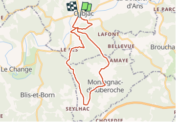

Length
15.4 km

Max alt
254 m

Uphill gradient
326 m
Km-Effort
19.7 km

Min alt
114 m

Downhill gradient
322 m
Boucle
Yes
Creation date :
2022-03-13 17:42:59.777
Updated on :
2022-03-31 14:44:25.98
4h28
Difficulty : Very difficult

FREE GPS app for hiking
 SityTrail
IGN / Geographical institutes
SityTrail Plus
The world is yours!
About
Trail Walking of 15.4 km to be discovered at New Aquitaine, Dordogne, Cubjac-Auvézère-Val d'Ans. This trail is proposed by houbart.
Photos


Positioning
Country:
France
Region :
New Aquitaine
Department/Province :
Dordogne
Municipality :
Cubjac-Auvézère-Val d'Ans
Location:
Cubjac
Start:(Dec)
Start:(UTM)
338069 ; 5009522 (31T) N.
Comments